Alaska–Nelson
Artist
Dorothy Nelson, USACreation Date
Late 1970s.Scale and Size
Original art scale: Not knownOriginal art size: 20.32 × 33.02 cm
Cropped digital art size: 50.66 × 34.28 cm at 300 DPI,
5,984 × 4,049 pixels
Terms of Use
No use restrictions. The shaded relief is in the public domain. Space permitting on your map, please cite Dorothy Nelson as the source.Georeferencing
Albers Equal-Area Conic ProjectionStandard Parallel 55N and 65N
Central meridian: 154W
Latitude of projection origin: 50N
NAD83 Datum
Note: Because the original projection of the relief could not be determined, Patterson manually transformed it in Photoshop to fit the Albers Equal-Area Conic projection with the parameters noted above.
Map Compatibility
Relief art modified by Tom Patterson to register with 1:10 million Natural Earth vectors: www.naturalearthdata.comThe relief download includes a Natural Earth coast shape file with embedded projection information.
Release Date
April 2010Additional Information
Original art created for R. R. Donnelley and Sons Cartographic Services and was published by Time Life, title not known. R. R. Donnelley and Sons Cartographic Services, now defunct, retained use rights and ownership of the art. Upon going out of business, Donnelley transferred ownership of the relief to GeoSystems Global Corporation, which later became MapQuest, owned by AOL. When MapQuest sold off their custom cartography unit, GeoNova, a successor company, obtained ownership of the shaded relief. GeoNova has since failed. GeoNova notified Herwig G. Schutzler of their intent to dispose of the shaded relief, which he rescued. Schutzler generously lent the original art to shadedreliefarchive.com for scanning before donating it to the U.S. Library of Congress, where it is permanently stored.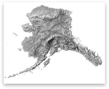
Download

9.4 MB
GeoTIFF with World file and coast shape file