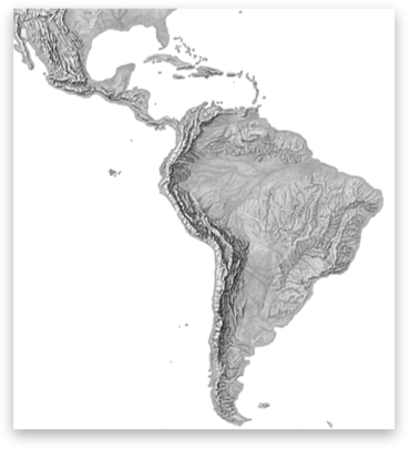
Latin America (Schutzler)
Artist
Herwig G. Schutzler, Lancaster, PA, USACreation Date
1970sScale and Size
Original art scale: 1:24,853,150Original art size: 40.64 × 38.1 cm
Cropped digital art size: 49.25 × 53.39 cm at 300 DPI,
5,817 × 6,306 pixels
Terms of Use
No use restrictions. The shaded relief is in the public domain. Space permitting on your map, please cite Herwig G. Schutzler as the source.Georeferencing
Lambert Azimuthal Equal-Area ProjectionCentral Meridian: 60W
Origin Latitude: 10S
WGS84 Datum
Map Compatibility
Relief art modified by Tom Patterson to register with 1:50 million Natural Earth vectors: www.naturalearthdata.comThe relief download includes a Natural Earth coast shape file with embedded projection information.
Release Date
April 2010Additional Information
Original art created for R. R. Donnelley and Sons Cartographic Services, publisher not known. R. R. Donnelley and Sons Cartographic Services, now defunct, retained use rights and ownership of the art. Upon going out of business, Donnelley transferred ownership of the relief to GeoSystems Global Corporation, which later became MapQuest, owned by AOL. When MapQuest sold off their custom cartography unit, GeoNova, a successor company, obtained ownership of the shaded relief. GeoNova has since failed. GeoNova notified Herwig G. Schutzler of their intent to dispose of the shaded relief, which he rescued. Schutzler generously lent the original art to shadedreliefarchive.com to scan before donating it to the U.S. Library of Congress, where it is permanently stored.Base map for shaded relief: Bolshoi Atlas, South America plate, page unknown
Download

8.2 MB
GeoTIFF with World file and coast shape file