Switzerland
Artists
Heinz Leuzinger.Creation Date
Date of first version not known. Extension in the northern part in 1999.Scale and Size
Original art scale and size: Not knownDigital art size at 520 DPI, 3,587 × 2,587 pixels.
The shaded relief is suited for maps at scales between 1:1,000,000 and 1:2,000,000.
Terms of Use
No use restrictions. The shaded relief is in the public domain. Space permitting on your map, please cite Heinz Leuzinger (Institute of Cartography and Geoinformation ETH Zurich) as the author.Georeferencing
The shaded relief image is not georeferenced, but it should align with data in the Swiss coordinate system (CH1903).Release Date
June 2011Additional Information
A first version of this shaded relief was drawn by Heinz Leuzinger for the Atlas of Switzerland, published in printed form between 1965 and 1997, and produced at the Institute of Cartography and Geoinformation of ETH Zurich. Heinz Leuzinger extended the northern part in 1999 for the printed version of the Hydrological Atlas of Switzerland.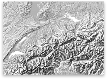
Download

6.5 MB
TIFF file