United States–Schutzler
Artist
Herwig G. Schutzler, Lancaster, PA, USACreation Date
1965Scale and Size
Original art scale and size: Not knownCropped digital art size: 62.85 × 40.28 cm at 300 DPI,
7,423 × 4,758 pixels
Terms of Use
No use restrictions. The shaded relief is in the public domain. Space permitting on your map, please cite Herwig G. Schutzler as the source.Georeferencing
Albers Equal-Area Conic ProjectionStandard Parallel 29.5N and 45.5N
Central meridian: 96W
Latitude of projection origin: 23N
NAD83 Datum
Map Compatibility
Relief art modified by Tom Patterson to register with 1:10 million Natural Earth vectors: www.naturalearthdata.comThe relief download includes a Natural Earth coast shape file with embedded projection information.
Release Date
April 2010Additional Information
Herwig G. Schutzler owns the original art. He has generously made it freely available for commercial and other purposes. April 2010 modifications by Patterson to the digital scan included extending the relief coverage slightly in Canada, redrawing parts of Mexico (this area was a mechanically added to the original relief and was out of alignment), and tonal balancing.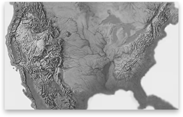
Download

21.9 MB
GeoTIFF with World file and coast shape file